![]()
|
|
|
|
|
|
|
|
|
|
|
|
The water sampling efforts at Little Diomede are one of three components of the Bering Strait Environmental Observatory, with marine mammal and shipboard benthic sampling the two other current components.
The
objective of the water sampling effort is to establish an onshore seawater
observatory at
Nutrient Survey Data. One of the issues that we have been resolving is whether water sampled at Little Diomede Island from our shallow water intake is representative of water as a whole flowing through the Bering Strait, or whether there are "island" effects that reflect contributions from the 3 million birds that nest on the island in the summer or human impacts from the 150 year-round residents. For seawater as a whole, we have used oxygen isotope analyses, which indicates that the water sampled at the island is almost identical (d18O = -1.1) to the Bering Sea signal that is present in the upper halocline of the Arctic Ocean. Nutrient analyses can help address the question of local inputs. We have now completed surveys of nutrients in surface and bottom waters in the vicinity of the island both in the winter and summer. The results indicate that "island" effects are very local (within 100-200 m) to the island, and we can expect to sample representative water masses as they pass the island through Bering Strait. Nutrient concentrations do vary in response to wind events and water mass boundaries, but anomalous concentrations appear to be limited and inshore of our proposed new undersea intake system. We have prepared .pdf files of a number of these surveys at the following ftp site, which are available for anonymous downloading: Nutrient Surveys
Contact us for a reprint of "The Potential for Using Little Diomede Island as a
Platform for Observing Oceanographic Conditions in Bering Strait," by L.W. Cooper, L.A. Codispoti,
V. Kelly, G.G. Sheffield and J.M. Grebmeier, Arctic
59(2):129-141, published in June 2006.
Our capabilities to pump water onshore for analysis on a 24/7 year-round basis
have been limited by storm and ice damage. Photos of a typical fall storm in October 2004. These
challenging issues remain, including development of reliable mechanisms for
bringing water onshore on a continuous basis year-round, in a remote community
that is strongly impacted by storms and seasonal sea ice. Data transmission
from the island via the internet has also been limited although we have
contributed to some recent satellite-based improvements..
With support from the National Science Foundation, and its arctic logistics
contractor, VECO Polar Resources, Inc.,
a geotechnical study was conducted in March-April, 2002, followed by a
feasibility study for a more permanent water inlet that will be drilled beneath
the shore, and be less vulnerable to storm and ice damage. A copy of the
feasibility study, prepared by Peratrovich, Nottingham and Drage, of Anchorage,
can be downloaded here as a .pdf
file. We have proposed to the National Science Foundation to follow up
this feasibility study with an engineering effort to directionally drill a more
permanent water intake system at Diomede. Another element proposed for
the water intake conduit will be fiber optics and electrical utilities to
support additional instrumentation at the point of the water intake. Two
examples of the type of directional drilling that are feasible at Diomede were
recently undertaken by U.S. Navy-supported teams at
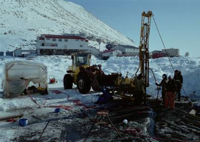 Geotechnical drilling (March 2002) to characterize sub-sea rock.
This information will be used to plan a proposed directional drilling operation
to develop a more permanent water intake system.
Geotechnical drilling (March 2002) to characterize sub-sea rock.
This information will be used to plan a proposed directional drilling operation
to develop a more permanent water intake system.
 Water pumping through the ice in April 2003. Photo by Dave
Brown
Water pumping through the ice in April 2003. Photo by Dave
Brown
Nearly continuous water column data collected from some of our interim efforts have now been largely edited and are available upon request. Each file includes approximately 50,000 lines of data, including salinity, temperature, inorganic nutrients, oxygen-18/16 ratios over different time increments (every 30 seconds to once daily). These data are being combined with other Arctic data for scientific use and eventual publication. For example, a copy of a presentation incorporating some of these data was made at the February 2004 Ocean Research Conference in Honolulu.
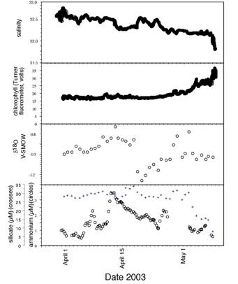
Data sample from spring of 2003. A modified version of this figure has been published in our June 2006 paper, published in the professional journal Arctic.
Ultimately,
our vision of the water sampling effort is a real-time data stream accessible
via the Internet from anywhere world-wide. In addition we will have a
web-searchable data archive such as is outlined below with quality-assured data
available to the scientific community and interested local users in the
Data Archives (THIS AREA IS UNDER CONSTRUCTION)
|
Please select the year. |
|
|
|
|
|
|
|
|
Please select the month. |
|
|
|
|
|
|
|
|
Please select the day. |
|
Please select the type of data. |
|
|
|
|
|
|
|
|
|
|
|
|
|
|
|
|
|
|
|
|
|
|
|
|
|