Northern Bering
and Chukchi
Seas 2007
Sir Wilfrid Laurier
![]()
![]()
![]()
![]()
![]()
![]()
![]()
![]()
Updates from the Laurier
Dispatch July 20th: The SubSea Camera
By: Will Burt and Markus Janout
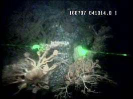
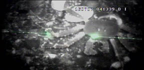
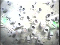
Upon entering the shallow shelf waters of the Bering Sea, we
started to apply a handheld camera system in order to film the
sea floor. The system is protected by a metal frame and includes
a subsea camera, temperature and pressure sensors, as well as two
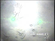
strong lights to illuminate the bottom. The reflection of two
laser pointers helps to determine the distance between camera and
the bottom. The camera system is connected to 130 m of sea cable
which is lowered by hand and transmits video images from the
seafloor to a deck unit and a handheld camcorder.
The procedure of the camera stations works as follows:
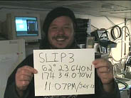
First, members of the crew or science party introduce the
location by holding up a sign
that lets us later identify the name, location and time of
recording (see picture). Stations are usually operated by two
people, one lowering the camera system, and one person monitoring
the live footage and give orders to lower or raise the camera.
This way we can determine the length of each station based on how
interesting the seafloor is at the location. Some recordings are
short and not useable due to low visibility or too strong
currents and others last for up to 40 minutes in biologically
diverse regions. Once filming is done, we then directly download
the footage onto a lab computer for review and some editing.
During the transect from the shelf south of SLI to the Chukchi
Sea we crossed several regimes, each characterized by certain
species. The bottom region south of St. Lawrence Island (SLI) is
clearly dominated and densely populated by brittle stars, which
have a small (1-2 cm) circular center with 5-6 thin arms. In the
following we crossed Anadyr Strait, located between Russia and
SLI. Currents there are very swift and the bottom is rocky as
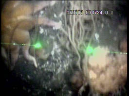
opposed to muddy areas with slow currents. The footage we
recorded in Anadyr Strait shows lots of colorful critters on the
rocky bottom, like sea urchins, corals, anemonies etc. Proceeding
northward of SLI, the benthic landscape changed to mainly crabs
and lots and lots of crater-like worm tubes often showing pink
ampharetid worm heads receding into their homes as the camera
passes by. The bottom of Bering Strait near Little Diomede
Island, AK provided the most spectacular underwater scenes with
boulders populated by corals, starfish, crabs, and anemones of
different colors (see pictures). Also, currents in Bering Strait
are very strong which makes it difficult to operate the camera.
Finally, after crossing the Arctic Circle into the southern
Chukchi Sea, where we found one area entirely covered by sand
dollars, the landscape changed to very turbid, low-visibility
waters, due to the outflow of highly productive waters through
Bering Strait.
The pictures below provide extracted stillshots of the underwater
recordings.
Tuesday-Wednesday July 10-12, 2007
by Jackie Grebmeier, Chief Scientist Dutch Harbor-Barrow, USA
The CGCS Sir Wilfrid
Laurier arrived Dutch Harbor, Alaska, USA at 0845 local time
on Tuesday, July 10 for a 5 hr port call. Chief Scientist Bill Williams disembarked to
return to Canada and three US scientists arrived to the ship: Dr.
Lee Cooper and myself from the University of Tennessee Knoxville
and Ms. Betty Carvellas, a high school science teacher from Essex
Junction, Vermont. The science and crew of the Laurier enjoyed
their short visit to Dutch Harbor, taking in the shopping sites
and walking the town. Scientists and crew visited the US
WWII memorial site on Unalaska Island.
All personnel were onboard the ship by the 1500 sailing time and the C30 program continued on its northward journey to the Arctic. We completed another station within 2 hrs of departing Dutch Harbor, including ADCP (for currents), CTD (conductivity-temperature-depth) sensors, water sampling (chemistry and biology) and bongo nets (zooplankton). The water sampling crew continues to sample the CTD/rosette and smiles abound.
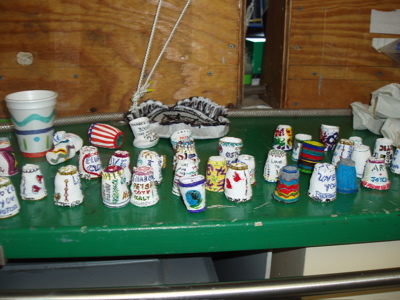 On July 11 we completed
another slope station (1000m) as we moved into deeper waters of
the SE Bering Sea on our way off the slope to a 3500m station,
the deepest sampling station of the cruise. The science party and
crew were busy designing colorful art on styrofoam coffee cups
for the deep deployment of the CTD. Why? Because the pressure at
this high depth causes the air to be pushed out of the styrofoam,
thus shrinking the cup to a fraction of their original size. So, besides getting great scientific data from
these deep casts, we have a “science experiment” that worked and
had fun doing it. After collecting our cups, we began sampling
upslope on July 12 to the shallow outer continental shelf (100m),
doing ADCP, CTD, water sampling and bongo nets at multiple
stations. Both a van Veen grab and box core were used to collect
sediments, which were sandy, on the upslope basin-to-shelf
transect.
On July 11 we completed
another slope station (1000m) as we moved into deeper waters of
the SE Bering Sea on our way off the slope to a 3500m station,
the deepest sampling station of the cruise. The science party and
crew were busy designing colorful art on styrofoam coffee cups
for the deep deployment of the CTD. Why? Because the pressure at
this high depth causes the air to be pushed out of the styrofoam,
thus shrinking the cup to a fraction of their original size. So, besides getting great scientific data from
these deep casts, we have a “science experiment” that worked and
had fun doing it. After collecting our cups, we began sampling
upslope on July 12 to the shallow outer continental shelf (100m),
doing ADCP, CTD, water sampling and bongo nets at multiple
stations. Both a van Veen grab and box core were used to collect
sediments, which were sandy, on the upslope basin-to-shelf
transect.
July 6, 2007
When embarking on a field season that takes you through the Gulf
of Alaska into the Bering Sea you never know what to expect. It
is always and adventure. We are onboard the CCGS Sir Wilfrid
Laurier steaming from Victoria, BC toward Dutch Harbor, AK
with 15 scientists from the U.S. and Canada on board. There are
lots of students on board who have never been to sea before.
They are soaking in the experience. There is lots to see as the
science party is taking a variety of samples during our transit.
Water samples are being taken from a CTD rosette for dissolved
oxygen, nutrients, salinity, barium, O-18, chlorophyll-a, and DMS/DMSP.
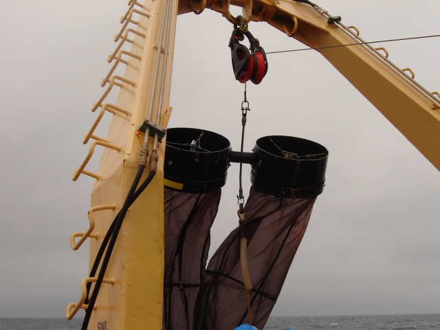
Bongo nets are being deployed to sample zooplankton in the water
column. Box cores will be taken at some of the deeper
sampling stations. The weather has been agreeable thus far.
Sampling continues.... Information
provided by Rebecca Pirtle-Levy